Monday, June 22, 2015

Wet Bottoms Trail


After our epic hike on Monday, we were not in any shape for anything too ambitious for the rest of the week.  However, we were feeling the for a bit of activity, so we decided to check out Wet Bottoms Trail in Cades Cove. This is a 1 mile long trail that connects Cooper Road trail with the Abrams Falls trail. It would be a great trail to take small children on. Grandkids, are you listening? Parts of it would probably be stroller friendly, but not the whole thing. For such a short trail, there is a lot to see.  You pass by a  barn, the Elijah Oliver homestead, and finish at the Abrams Falls trailhead, where there is a nice stream to cool your feet.  An added bonus was the beautiful rhododendron blooming.
         
 This was an upscale cabin with several glass windows and multiple rooms. 
 The springhouse


Wednesday, June 17, 2015

Who goes to Cape Cod in January?

1/30/15  A Pappy and Gigi who miss their grandkids, that's who!  We found a good price for the flight, and were lucky to get in and out between snowstorms.  We were there for the Super Bowl, which the Patriots won, so it was a good time for all!
Obviously I'm very behind on posting, but I want to remember the trip, so bear with me
Steve finally got to see his newest grandaughter
Josiah is learning from the master!

These kids love each other so much!  It's wonderful to see how good Sarah and Josiah are with Lydia.

They had a lot of snow!  It was over 3 feet deep in their yard.  Fortunately the city keeps the streets plowed, so getting around wasn't a problem.  Both of these snow pictures were taken by David.


My girls!

Tuesday, June 16, 2015

Lower Mt. Camerer

5/25/15  Today we hiked the Lower Mt Camerer Trail from Cosby Campground to Campsite 35, with a short side trip to Sutton Ridge, for a total of 7.4 miles.  Although long, it was a fairly easy trail.  The mountain laurel were in full bloom, and I don't think I've ever seen so many of them.  It was like walking through a tunnel of flowers. 
The ladies; Gina, Vicky, Alice, Mary Ann

The hammock garden at the backcountry campsite.  If we take a long hike, we definitely stop for a rest in the middle of the day.  One tree had 3 hammocks attached to it.  Gina in front, Vicky on left, and Alice on right.  Mary Ann is in the background

Squaw Root.  Although considered a wildflower, it is parasitic and has no chlorophyll.  It's one of the first things to come out in the spring, and is an important food source for bears. 


Mountain Laurel tunnel.
Gina & Vicky in front, back l-r :Hank, Mary Ann, Alice, John, Larry, Steve

How many people can you get in  a selfie?
My thanks to Gina for the last 2 pictures.

Gregory Bald Hike

Front:  John, Vicky
Back :Hank, Gina, Cindy, Sam, Steve, Bill
6/15/2015  We had been looking forward to this hike for ages!  Of course the trail can be hiked any time of year, but we specifically wanted to go in mid-June, because the flame azaleas are blooming then. 
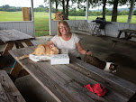
The hike actually started the night before, when we gathered for a delicious spaghetti dinner at Hank and Margaret's house.  Carb-loading to the max!  I think we all ate too much!
A funny side story, when I uploaded the photo the right to Facebook, it immediately zeroed in on my face, and identified me as my daughter, Jacki.  Way to start the day!
John, Gina, Hank, Sam, Cindy, Vicky, Steve
There are two ways to get to Gregory Bald, and neither one is easy!  We chose the shorter, less steep route that involved more driving.  Gina's husband, Bill was recovering from knee surgery and not hiking yet, however he was cleared to drive.  He graciously agreed to drop us off at the Trailhead, drive many miles along a winding gravel road, kill some time, and meet us at Twentymile ranger station late that afternoon.   As we turned onto Parson's Branch Road, we were greeted the by furry fellow above.  He wasn't too concerned by our presence. We left the house at 6:45 and were on the trail by 8:30.
We hiked to a backcountry campsite near the bald, and left our packs there.   The park service provides a cable system to hang packs and anything that might contain food, out of the reach of bears.  It's harder than it looks to hoist those packs up high!  We felt it was important, since we had already seen one bear, and seen lots of "calling cards" on the trail.  We walked another 1/2 mile( the steepest part of the whole trail) to the bald, spent some time there and came back for lunch and a rest.

This fungi was growing along the trail.  Beautiful orange color!

I will lift my eyes to the hills, where my help comes from.  My help comes from the Lord, who made heaven and earth.
 Psalm 121
 And what a beautiful earth He made!  Could you imagine spending the summer up here, grazing your livestock?  That's what the early settlers did.  After getting extremely hot on the trail, it was wonderful to enjoy this view, and the cool breeze  that was blowing.  The view is looking down in to Cades Cove.

The Flame Azaleas were just beautiful.  They occur in every shade from yellow-orange to a bright reddish pink.  They were everywhere, and each one was prettier than the last one.  The bald covers 14 acres, and I think we walked every inch of it. 


 All too soon, it was time to hit the trail again.  Although the rest of the adventure was mainly downhill, we had over 7 miles to go.  The downhill trip was uneventful, and we sure were glad to see Bill and his cooler full of drinks at the end! 
Thanks to Gina for these two photos and to Hank for the "people" photos and the bear picture.

This was the longest hike I have ever done, and I am proud that I completed it,even if I was the last one in (only by about a minute).  Even better was the good friends I got to enjoy it with. 


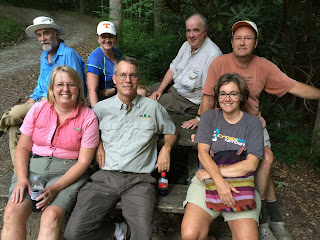
The end of the trail.  Notice we are all sitting, boots off, and most of us have a cold drink in our hand.  We were a hot, sweaty, fragrant(!) but very happy bunch in the car on the way home! 


Monday, June 15, 2015

Appalachian Trail to the Jump Off

5/12/15 I have no idea why they call this the Jump Off, but it sure is beautiful! This trail starts at Newfound Gap, and goes north along the Appalachian Trail for a couple of miles.  It is very rocky and rugged, and mostly uphill.  Eventually you come to the small trail to the Jump Off, which is shorter  but more steep and rocky.  The view is certainly worth it!  Plus it's downhill on the way back!


I was not expecting to see wildflowers on this trail.  It was really too late for most of the spring wildflowers, but we were at a higher elevation, so spring comes a bit later.  These are fringed phacelias, but we also saw red trillium, violets, spring beauties, and many others.


This grouse was in the trail, and was in no hurry to leave.  We thought it was a pretty bad place to build a nest, but what do we know?

Sunday, June 14, 2015

Meigs creek to Lumber Ridge to Tremont.

5/28/15  We started out on Meigs Creek trail, which has over 20 small creek crossings.  Last summer when we hiked this trail, I managed to slip and fall in the water, but this time every crossing was uneventful.  When we came to the intersection of Curry Mountain, Lumber Ridge and Meigs Creek, where we planned to eat lunch, there was a large hiking club there doing the same thing.  They were very friendly, and we enjoyed some nice conversation. We also met some of the trail maintenance crew, and expressed our appreciation for the hard work they do.
 Since the trail was going to be pretty crowded, we decided to take the manway, (an old unmaintained trail) down to Tremont.  That proved to be a good decision, in that it was not crowded, but unmaintained is the word of the day.  It was a good challenge for all of us.  We ended up at Spruce flats Falls, then at Tremont.

Galax blooming

Steve and our friend Hank

Spruce Flats falls.  The last time we were here, it was very crowded, and we never did get a decent picture.  It's only a short way up to Tremont (where the car was ) from here, but what a climb!


Saturday, June 13, 2015

Andrews Bald

June 9, 2015  Steve and I, along with Hank Dye, hiked to Andrews Bald.  This trail starts at Clingmans Dome, and goes down 1.7 miles to the bald. That means an uphill climb on the way back, which I dislike, but the bald was so pretty that it was worth it.  The flame azaleas were starting to bloom, and were just beautiful. The view wasn't bad either! 


Friday, June 12, 2015

Old Settlers Trail

5/20/2015  As we have done more hiking, we keep discovering new trails to explore.  The Old Settlers Trail is in the Cosby area, and is not heavily used. In fact, the 5 (Steve & I, Hank, Grady and Sam) of us didn't see another hiker the entire day. 
The mountain laurel were in full bloom.

There was lots of evidence of prior homes, rock walls, and other signs of the community that was here before the park was formed.


The entire trail is about 15 miles long, and we only hiked about 2.5 miles of it.  Eventually, we'll get to the rest of it.