Showing posts with label hiking. Show all posts

Monday, June 22, 2015

Wet Bottoms Trail


After our epic hike on Monday, we were not in any shape for anything too ambitious for the rest of the week.  However, we were feeling the for a bit of activity, so we decided to check out Wet Bottoms Trail in Cades Cove. This is a 1 mile long trail that connects Cooper Road trail with the Abrams Falls trail. It would be a great trail to take small children on. Grandkids, are you listening? Parts of it would probably be stroller friendly, but not the whole thing. For such a short trail, there is a lot to see.  You pass by a  barn, the Elijah Oliver homestead, and finish at the Abrams Falls trailhead, where there is a nice stream to cool your feet.  An added bonus was the beautiful rhododendron blooming.
         
 This was an upscale cabin with several glass windows and multiple rooms. 
 The springhouse


Tuesday, June 16, 2015

Lower Mt. Camerer

5/25/15  Today we hiked the Lower Mt Camerer Trail from Cosby Campground to Campsite 35, with a short side trip to Sutton Ridge, for a total of 7.4 miles.  Although long, it was a fairly easy trail.  The mountain laurel were in full bloom, and I don't think I've ever seen so many of them.  It was like walking through a tunnel of flowers. 
The ladies; Gina, Vicky, Alice, Mary Ann

The hammock garden at the backcountry campsite.  If we take a long hike, we definitely stop for a rest in the middle of the day.  One tree had 3 hammocks attached to it.  Gina in front, Vicky on left, and Alice on right.  Mary Ann is in the background

Squaw Root.  Although considered a wildflower, it is parasitic and has no chlorophyll.  It's one of the first things to come out in the spring, and is an important food source for bears. 


Mountain Laurel tunnel.
Gina & Vicky in front, back l-r :Hank, Mary Ann, Alice, John, Larry, Steve

How many people can you get in  a selfie?
My thanks to Gina for the last 2 pictures.

Gregory Bald Hike

Front:  John, Vicky
Back :Hank, Gina, Cindy, Sam, Steve, Bill
6/15/2015  We had been looking forward to this hike for ages!  Of course the trail can be hiked any time of year, but we specifically wanted to go in mid-June, because the flame azaleas are blooming then. 
The hike actually started the night before, when we gathered for a delicious spaghetti dinner at Hank and Margaret's house.  Carb-loading to the max!  I think we all ate too much!
A funny side story, when I uploaded the photo the right to Facebook, it immediately zeroed in on my face, and identified me as my daughter, Jacki.  Way to start the day!
John, Gina, Hank, Sam, Cindy, Vicky, Steve
There are two ways to get to Gregory Bald, and neither one is easy!  We chose the shorter, less steep route that involved more driving.  Gina's husband, Bill was recovering from knee surgery and not hiking yet, however he was cleared to drive.  He graciously agreed to drop us off at the Trailhead, drive many miles along a winding gravel road, kill some time, and meet us at Twentymile ranger station late that afternoon.   As we turned onto Parson's Branch Road, we were greeted the by furry fellow above.  He wasn't too concerned by our presence. We left the house at 6:45 and were on the trail by 8:30.
We hiked to a backcountry campsite near the bald, and left our packs there.   The park service provides a cable system to hang packs and anything that might contain food, out of the reach of bears.  It's harder than it looks to hoist those packs up high!  We felt it was important, since we had already seen one bear, and seen lots of "calling cards" on the trail.  We walked another 1/2 mile( the steepest part of the whole trail) to the bald, spent some time there and came back for lunch and a rest.

This fungi was growing along the trail.  Beautiful orange color!

I will lift my eyes to the hills, where my help comes from.  My help comes from the Lord, who made heaven and earth.
 Psalm 121
 And what a beautiful earth He made!  Could you imagine spending the summer up here, grazing your livestock?  That's what the early settlers did.  After getting extremely hot on the trail, it was wonderful to enjoy this view, and the cool breeze  that was blowing.  The view is looking down in to Cades Cove.

The Flame Azaleas were just beautiful.  They occur in every shade from yellow-orange to a bright reddish pink.  They were everywhere, and each one was prettier than the last one.  The bald covers 14 acres, and I think we walked every inch of it. 


 All too soon, it was time to hit the trail again.  Although the rest of the adventure was mainly downhill, we had over 7 miles to go.  The downhill trip was uneventful, and we sure were glad to see Bill and his cooler full of drinks at the end! 
Thanks to Gina for these two photos and to Hank for the "people" photos and the bear picture.

This was the longest hike I have ever done, and I am proud that I completed it,even if I was the last one in (only by about a minute).  Even better was the good friends I got to enjoy it with. 
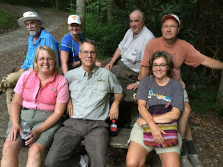

The end of the trail.  Notice we are all sitting, boots off, and most of us have a cold drink in our hand.  We were a hot, sweaty, fragrant(!) but very happy bunch in the car on the way home! 


Sunday, June 14, 2015

Meigs creek to Lumber Ridge to Tremont.

5/28/15  We started out on Meigs Creek trail, which has over 20 small creek crossings.  Last summer when we hiked this trail, I managed to slip and fall in the water, but this time every crossing was uneventful.  When we came to the intersection of Curry Mountain, Lumber Ridge and Meigs Creek, where we planned to eat lunch, there was a large hiking club there doing the same thing.  They were very friendly, and we enjoyed some nice conversation. We also met some of the trail maintenance crew, and expressed our appreciation for the hard work they do.
 Since the trail was going to be pretty crowded, we decided to take the manway, (an old unmaintained trail) down to Tremont.  That proved to be a good decision, in that it was not crowded, but unmaintained is the word of the day.  It was a good challenge for all of us.  We ended up at Spruce flats Falls, then at Tremont.

Galax blooming

Steve and our friend Hank

Spruce Flats falls.  The last time we were here, it was very crowded, and we never did get a decent picture.  It's only a short way up to Tremont (where the car was ) from here, but what a climb!


Wednesday, November 5, 2014

Early snow and a thru hiker


This past weekend we had the privilege of hosting a thru hiker for a few days. Trevor is the grandson of one of our FL neighbors, and is hiking the Appalachian Trail, from Maine to Georgia.  It is over 2000 miles in length, and as you might imagine by the time a hiker gets to the Smoky Mountains, they might need a break! Trevor had planned to be at Newfound Gap on Friday, long before a major winter storm was forecast. We met him about noon, and the storm rolled in that night. Another example of God's perfect timing. 
We had about 4" of snow at the house, and there was almost 2 feet at Newfound Gap.   The roads in the park were all closed, and Trevor ended up with us for 3 nights instead of the one we had planned.  We were all grateful that he didn't have to spend those nights out in way below freezing temperatures! By Monday the roads were open, and he set out again, and sent us this picture the next day.  There is STILL snow on the ground at the higher elevations, and lots of tree branches down everywhere.

Sunday, November 2, 2014

Bote Mountain

October 29, 2014. Finley Cane, Bote Mountain, Lead Cove loop. 
 The fall colors were at their peak in the Cades Cove area, so although this hike offered very few long range views, the colors were beautiful.


 The trail intersection where we ate lunch.  It was all downhill from there!

Saturday, November 1, 2014

Charlie's Bunion hike

Funny name, great hike. We had a group of 8 today, 2 women and 6 men.  This is one of the harder hikes that I've done.  It's 8 miles total, with some pretty significant elevation change, and a very rocky trail.  I was thankful for my hiking poles!   Most of the hike was along the Appalachian Trail, with a short side trail to the destination.
The story is that this rocky area was named by Horace Kephart, one of the early park rangers, in honor of the state of his friend's feet after a long hike.  It started out as a joke, and the name stuck.  I have to say that my feet were very tired and sore after this hike but they sure didn't look that bad!
 This rock cliff is almost vertical.  Very rugged country.
 Steve at the tip of the bunion.  It's straight down from there!

 It was a warm day, so we were all hogging the cool spot.  Steve, Sam and John, contemplating climbing out onto the rocks.
 Some amazing lichen.
Our intrepid group.  From left, Larry, Larry, John, Hank (orange shirt), Sam (dark shirt), Gina (in back) Vicky, Steve 

Friday, October 31, 2014

Indian Flats Falls

Oct 24, 2014  Steve and I decided to hike to Indian Flats Falls, near Tremont.  These falls are not marked on any of the park maps, for some reason but most of the locals know the way.  The trail is actually an old railroad bed, leftover from the logging days before the park was formed. Now it is a horse/hiking trail.  Although it is an 8 mile round trip, it is a very gentle climb and follows the river most of the way.  There are numerous small waterfalls and cascades along the way and it was a very pleasant hike.  We saw several horse groups(usually we only see their "calling cards")  We will definitely hike this spot again.
We hiked this far with our grandson Eli last spring.  We sat on this bench and ate a snack before heading back.  Eli had just turned two and hiked over two miles that day.  Let's just say he took a real good nap!


We think this was from one of the logging camps.  There was a stone wall surrounding this chimney that we think was the foundation of the building.


Steve is looking at a stovepipe, and a rail from the railroad.


The falls!  This would be even more wonderful on a hot summer day.