Friday, November 14, 2014

Old Sugarlands trail & rock house

 11/10/14  This 7 mile hike involved a two car shuttle, or else a LOT of walking.  We opted for the two cars, since there were 8 of us anyway.  We parked at the trailhead near Gatlinburg and ended up at the  Sugarlands visitor center.  This is a beautiful trail, nice and wide and well padded with pine needles, but is also used for horses, so you have to watch where you step! About halfway down, we took a manway(old trail that is no longer maintained) to an old cemetery and a "rock house".  These aren't on any of the park maps, and the rangers officially know nothing, but obviously a lot of people know about them.  At the cemetery we talked to a lady who was visiting the graves of her great grandparents.
The rock house is exactly what it sounds like, a house made of rocks.  The roof, windows, etc. are all gone but surprisingly there isn't much vandalism (probably because it's not on the map).  There are no clear cut records, but the most popular theory is that the house was a home/office for the superintendent when Hwy 321 was put in.


This house was built to last!   I was coveting the cast iron skillet!
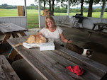
 Hank, Pat and Helen lounging in the "living room"
Wouldn't you like to have this in your backyard?

Beautiful day, beautiful trail, great companions, what more do you want?

Front:  Hank in his orange Vols hat, Sammy, John, who was racing to get in the picture before the timer went off.
Back left:  Pat & Helen, Alice (green shirt) Vicky, Steve

Thursday, November 13, 2014

Gatlinburg Trail

 November 3, 2014

After sending our thru-hiker (He finished! if you are interested in reading more )on his way, we decided to do a short walk on the Gatlinburg trail.  This trail is really more of a jogging/biking trail, and is one of the more level trails in the park.  Pets are also allowed, so we saw a lot of dogs and all were well behaved!  We began at the back of the Sugarlands Visitor center, walked 2 miles to Gatlinburg, had lunch and walked back.  Definitely one of our easier hikes, but still enjoyable. 

As we returned to the visitor center, we came across this monument to the CCC.  In our hikes, we have come across the remains of a lot of CCC camps, and learning the pre-park history of the area is very interesting to me.  My grandfather was a supervisor in the CCC near Morristown, TN, so seeing these remains always reminds me of him. 

Sunday, November 9, 2014

How do you tag a butterfly?

That was the burning question of the day.  Steve and I were invited to a Monarch Tagging event, hosted by our friends Hank and Margaret.  The event was sponsored by the Smoky Mountain Institute at Tremont , which is not far from our house.  They host science camps for kids and families, and participate in a variety of worldwide research projects, such as monitoring salamanders, banding birds, and tagging Monarch butterflies. 

It turned out to be a cold rainy day, and there was not a butterfly in sight, but we had fun anyway.  And to answer the question, you tag a butterfly by placing a sticker with a unique number on it, on a certain spot on the underside of the wing.  If you ever find a dead monarch, look at its wings, and you may find one that's tagged.

Following is a YouTubevideo put together by one of the participants, Gina.  For some reason, it doesn't seem to play well on a mobile phone, but is fine on a laptop or desktop.  Enjoy!
 http://youtu.be/5OXkd4VsHfs

Wednesday, November 5, 2014

Early snow and a thru hiker


This past weekend we had the privilege of hosting a thru hiker for a few days. Trevor is the grandson of one of our FL neighbors, and is hiking the Appalachian Trail, from Maine to Georgia.  It is over 2000 miles in length, and as you might imagine by the time a hiker gets to the Smoky Mountains, they might need a break! Trevor had planned to be at Newfound Gap on Friday, long before a major winter storm was forecast. We met him about noon, and the storm rolled in that night. Another example of God's perfect timing. 
We had about 4" of snow at the house, and there was almost 2 feet at Newfound Gap.   The roads in the park were all closed, and Trevor ended up with us for 3 nights instead of the one we had planned.  We were all grateful that he didn't have to spend those nights out in way below freezing temperatures! By Monday the roads were open, and he set out again, and sent us this picture the next day.  There is STILL snow on the ground at the higher elevations, and lots of tree branches down everywhere.

Sunday, November 2, 2014

Bote Mountain

October 29, 2014. Finley Cane, Bote Mountain, Lead Cove loop. 
 The fall colors were at their peak in the Cades Cove area, so although this hike offered very few long range views, the colors were beautiful.


 The trail intersection where we ate lunch.  It was all downhill from there!

Saturday, November 1, 2014

Charlie's Bunion hike

Funny name, great hike. We had a group of 8 today, 2 women and 6 men.  This is one of the harder hikes that I've done.  It's 8 miles total, with some pretty significant elevation change, and a very rocky trail.  I was thankful for my hiking poles!   Most of the hike was along the Appalachian Trail, with a short side trail to the destination.
The story is that this rocky area was named by Horace Kephart, one of the early park rangers, in honor of the state of his friend's feet after a long hike.  It started out as a joke, and the name stuck.  I have to say that my feet were very tired and sore after this hike but they sure didn't look that bad!
 This rock cliff is almost vertical.  Very rugged country.
 Steve at the tip of the bunion.  It's straight down from there!

 It was a warm day, so we were all hogging the cool spot.  Steve, Sam and John, contemplating climbing out onto the rocks.
 Some amazing lichen.
Our intrepid group.  From left, Larry, Larry, John, Hank (orange shirt), Sam (dark shirt), Gina (in back) Vicky, Steve